Thursday, 13th of June,
I have been looking forward to this stage of the trip for some 6 months. Finally we were on our way towards Ayers Rock and the Western Australian Border. Within less than an hour, we caught glimpses of Ayers Rock, (Uluru as it is called today).
(Lesley’s photo)

Driving into Yalara, I was completely surprised. I was expecting a typical outback town, but the reality was a resort, the Ayers Rock Resort. We emptied our cassette, topped up the fuel tank and did a bit of shopping at the IGA supermarket. Having a good internet connection, I managed to post my latest blog entries, update the maps on everytrail.com, log my finds of caches (as well as my ‘Did not find’) on geocache.com and get all my emails from the last three days. I also checked what caches were in the area and decided to check out the ‘Yulara Lookout’ cache. I approached the cache cross country from the parking lot we were at near the IGA. Within some 100 meters I passed by this fenced off area. ‘Boomerang and Spear throwing in progress’ warned a site. I made sure I passed the area quickly, especially after I saw a boomerang overhead.
The cache was an easy find and the view was magnificent. Where would you expect to find the cache?
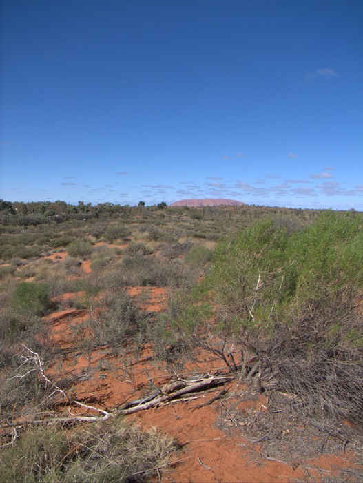
Soon we were on our way, having arranged to meet up where the bitumen ends. Not far out of town we spotted The Olgas (now officially named Kata Tjuta) in the West.
(Lesley’s photo)

We still could see Ayers Rock in the East.
(Lesley’s photo)

In a way, I found The Olgas more impressive. Soon we arrived at a viewing area which is on top of a sand dune. We stopped in the parking area near a desert oak.

We walked up the sand dune along a path which was a steel mesh laid to protect the environment. I found the desert oaks very impressive. In the back ground you can see Uluru, Ayers Rock.

The view from the viewing area on top of the sand dune was incredible. In front of us The Olgas.
(Lesley’s photo)

Turning east we still could see Ayers Rock (Uluru).
(Lesley’s photo)


(Lesley’s photo)

We were fortunate that we had the viewing area to ourselves. Minutes later a tourist bus arrived and many people ascended the sand dune as we returned to the car.
Turning off the road to The Olgas towards the WA border, we were immediately on dirt road. Time to lower tyre pressure to ease the pain of the corrugations. We were still in view of The Olgas.
(Lesley’s photo)


Having lowered the tyre pressure, we were ready to start the long dirt road trip, the Outback Way, the longest shotcut in the world.

Travelling was not too difficult, as long as we kept our distance behind Kay and Bruce. You certainly didn’t want to be too close to the dust thrown up by them as we travelled along.


After about half an hour’s driving we stopped to make sure everything was OK. I checked tyre and hub temperatures, while Lesley checked the inside of the van. Everything was fine.


Time was getting on and we were looking out for a spot to spend the night. Val and Chris spotted a possibility around 2:45pm. It certainly was a well chosen camp spot and we were soon parked up for the night.

We all gathered firewood and soon Bruce had a fire going. We sat around and talked about everything and nothing in particular. A lovely afternoon.

I enjoyed exploring the area around the camp site. Here are a few of the photos I captured.


It wasn’t long before the sun settled behind the horizon. Time for us to go inside as it was getting rather cold.

Lesley prepared a lovely meal and it was an early night for us. Just before retiring I went outside. There was a sliver of a moon and the stars were incredible. No other lights to disturb the night sky.

Glad to see you are having a good time.